Today we had what seemed like a busy day. In the end however we only ended up driving a little over 250 miles, which really isn’t much at all. Being that today is our anniversary, we slept in today and relaxed for much of the morning. We grabbed some yogurt, juice, cereal and biscuits & gravy at the hotel’s continental breakfast. It didn’t fill us at all but that would prove to not be a problem. We didn’t get actually moving until just about 11:30 this morning which is very late for us. We headed back north to Santa Barbara which was only about 10 miles from where we stayed in Carpinteria, CA. We wanted to check out yesterday’s fig tree in the daylight. We were glad we went back. The tree was very impressive. We tried taking pictures but the pictures do not do the tree justice. We just couldn’t capture the enormity of the tree in our photos. Some of the roots were above ground, we can only guess because they are so large, and the above ground parts of the roots were still 2-4 feet high! The tree is not especially tall but it certainly wide and provides shade for practically a city block.

 |
| Notice the size of the car next to the tree and roots |
After visiting the fig tree we headed for lunch. This would end up being our last meal of the day. We had read about a Mexican restaurant on roadfood.com which was in Santa Barbara. The restaurant was so good that there was often a line out the door and around the block. We had to go. When we got there, sure enough, there was a line. We quickly parked the car in a 90 minute parking space and got in line. We are not sure how long we waited in line but at the end of our meal our 90 minutes was about up. This place was not exactly a restaurant with waiter service, it was more place your order at the window, wait for them to call your number and take your food to a table. We ordered a bunch of stuff, some of which we have had before and some of which we had never tried. We washed it all down with a Corona and horchata, both of which always go great with spicy food. The line never got short the entire time we were there. We left full and with to-go boxes because we could not finish it all.


 |
| Enchaladas de plaza |
 |
| Sopes de Pollo |
 |
| Super Rica Especial |
 |
| Tamal de Verduras |
After filling up on lunch and dinner we headed south to Ventura to the Mission San Buenaventura. Had we discovered these missions sooner we probably would have gone to others on this trip. Now we have a reason to return. Since we were there during regular hours we actually took a tour of the church and the grounds rather than just the church. This mission had a small museum attached which contained all kinds of artifacts from the years the mission has been there. One thing that stood out was a wooden bell. This mission was the only mission to use a wooden bell, we thought that was kind of neat. After spending some time at the mission we were on our way again.


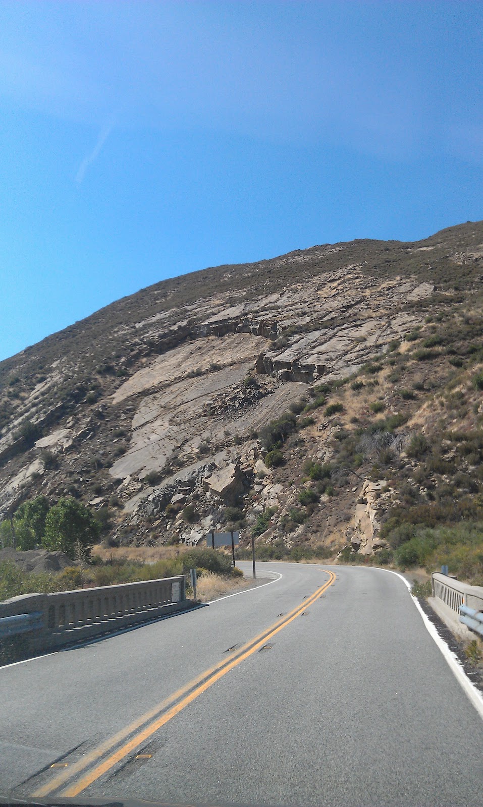
We were not yet sure where we would be spending the night and Chris only had one other thing he wanted to see in California so we had time to take the scenic route. Vegas, where we need to be Saturday morning at 930 A.M., was only a 6 ½ hour drive from where we stayed last night so we had some time to explore a little bit. Rather than drive through Los Angeles and all of its wonderful traffic and freeways we decided to take a route which would completely avoid the city. Chris had read about a particular route around L.A. in a book that just so happens to be by one of Jackie’s least favorite people, Neil Peart. Had Jackie known that Chris found out about Rte. 33 and the Lockwood Valley Road from one of his books she would have definitely said let’s go sit in traffic. But she didn’t ask and he didn’t say. So we took route 33 north from Ventura. The road twists and turns and climbs from the ocean to about 5000 feet in about 30 miles. The temperature in those 30 miles also went from high 60’s to high 90’s. We found it amazing how much the scenery changed. Things went from very cool and green to hot and completely dry. We could see why there are so many fires each year in California. Most of the leaves on trees were brown, even some of the evergreen trees were turning brown. When we got out of the car at various pull-offs things were so dry that you created dust just walking around. At one of the pull offs Chris was going to help ensure that the ground stayed moist but he didn’t think that was fair to Jackie who prefers a toilet to rustic style. So we held it. The road had very little traffic. We probably passed less than 50 cars in those 30 miles to the top and the road was probably never straight for more than a quarter of a mile. You couldn’t travel very fast on this road but it was sure fun to drive (or so Chris says). We also noticed that numerous signs warning drivers of rock slides. We saw evidence of dozens of rock slides from small ones which leave dirt and rocks on the road to large, take out the highway for 2 weeks rock slides. Once we crested the summit and started back down the other side the scenery reminded us of the Grand Canyon, or at least the desert areas around the Grand Canyon. We also noticed the quietness. The sound of nothing is truly something that should be experienced and can’t really be explained. Once we stopped and turned off the car there were truly no sounds at all. It was just very peaceful. We turned onto a road called Lockwood Valley Road, which went east from route 33 through Los Padres National Forest. This road was also twisty and turny, at least in the beginning. This road didn’t have as many landslide warnings but there were several places where the road crossed arroyos (dry streambeds) without bridges. While they were dry now we could see that when it rains the road probably gets completely flooded over. This would be really cool to see but at the same time it would mean we would probably have to backtrack 50 miles. We also noticed that in past years there appeared to be major forest fires along this road. We later learned that the burnt areas we saw were from fires in 2006. We also learned that only two months ago the area around Rte 33 and Lockwood Valley Rd. junction was closed due to a smaller fire in the area which has now been extinguished.
 |
| Evidence of a landslide |


After we made our way out of the National Forest we got onto I-5 for a short time. While the speed limit was either 65 or 70 (we tend not to notice these things…see blog from last week), we did notice that the right lane was full of trucks and the truck speed limit was only 35. We quickly found out why. The interstate very steeply went downhill for about 6 miles. We actually saw several runaway truck ramps instead of the normal 1 or 2 you might see. We even saw some on the left side of the road, presumably for trucks that are really out of control. Fortunately the runaway truck ramps were not in use today. We got off of the interstate after about 20 miles and headed east again on a back road towards Route 58, which while not an interstate, was built to interstate standards. They call everything built like an interstate the freeway out here. All interstates are freeways, many US roads are freeways and many state roads are freeways, all with controlled access with freeway speed limits.
Once we got on highway 58 we headed south for just a few miles before exiting once again for something a little bit different. We stopped at Tehachapi Loop. Tehachapi Loop is a long spiral along a rail line which allows the railroad to gain a lot of elevation in a short amount of distance. What makes this interesting is that the railroad loops around, continually going uphill, and actually passes over itself. So if you get a long enough train, the train will actually pass over or under itself as it goes up or downhill. Chris had always known this existed and at the beginning of this trip we had not planned on coming here. When we were at Donner Pass last Chris was noticing trains struggling up the mountain and wondered why they chose to cross the mountains there. He then read a little on the railroad mountain crossings and he came across references to this loop. When he looked at its location on a map we realized that we may be in the area so if we were and if we had time, we would check it out. While we were there a couple of trains did pass by and we got a picture of a train passing under itself.

After leaving Tehachapi Loop we headed for our hotel, which tonight would be in Palmdale, CA. Somewhere along the way Chris made a reservation at a Holiday Inn once again using the app. We chose Palmdale because we could get a hotel room for only 5000 points. This is one of the reasons we stay often at Holiday Inn properties. You can accumulate points very quickly using unadvertised specials which are available on the web if you know where to look. It is not uncommon for us to earn 10000 or 15000 points on a single night stay. Usually a free night at a higher end Holiday Inn property, such as one in the heart of Manhattan, or in Hawaii, would cost 35000-50000 points per night. A hotel room in a smaller city might cost 25000 points per night and a room at a Holiday Inn Express along an interstate someplace might cost 15000 per night. You can see that if we are earning 10000 points per night, free nights add up rather quickly. Every so often, at properties that might be less busy, they offer specials where you can get a free night for only 5000 points. Think of it this way: Buy one night, get 3 nights free if you can find the properties that have these specials. Palmdale had one such special going on now so as long as Palmdale was within an hours’ drive of where we would be, that is where we would be staying.
Along the way we passed by a mountain full of windmills. There were hundreds of windmills all over the top of the mountain, spinning away generating electricity for someone. At first they seemed ugly but they grew on us and they kind of looked neat. We suppose if they wanted to put them near our house we may not like it as much. Also, as we were driving we saw out of the corner of our eye what looked like dozens of jet planes lined up in the desert. We had read about a jet boneyard in Mojave, CA before and this was it. Due to the dry conditions in the desert many airlines store planes here that are either not in service or they are keeping around for parts. We drove around the perimeter of the airport (probably 5 miles on each side) looking for a way in but we could not find one. Finally we noticed that there was a geocache near the middle of the airport so we followed the directions for that and we found ourselves closer to the planes, but still not close enough to get good pictures. We looked it up and found that this boneyard is on roadsideamerica.com. We took note of that website and promised ourselves we would use it more. We would have liked to tour the place but we later found out that tours are not given.


Just before we got to our hotel we commented that we think we only filled up on gas 3 or 4 times so far on this trip. This is very good compared to times when we have a Suburban or a Tahoe and we decided we like this Durango. We may even rent these or something similar from now on when we take trips. They are spacious, comfortable, much better on gas than what we usually rent, and they go fast!
Some other stuff we saw along the way:
 |
| Hells Angel in front of us |
 |
| Pizza Pizza! |
 |
| Today's route |
 |
Maybe next time
|


No comments:
Post a Comment